Redding, CA
August 20, 2012
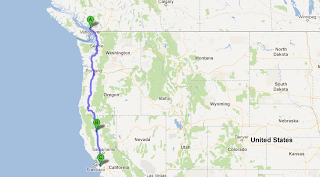
Driving home to San Jose from Vancouver, 982 miles, 1583 Canadian.
For years, every time we've passed through Redding, I've thought about stopping at the Sundial Pedestrian Bridge. And it is so close to the freeway!
This is part of an enormous natural system that includes Lake Shasta.
The museum knows its audience. We didn't stop by the museum as we had been on the road for about a day and were pretty interested in getting home.
The bridge is magnificent. Here is it is from a borrowed aerial view:
| From http://www.redding-real-estate.com/ |
And my view from the ground.
From the web site, Environmental Graffiti:
The stylish Sundial Bridge across the Sacramento River is a glass-bottom bridge that connects a network of walking and biking trails. The requirement before planning the bridge was that it could not cast too much shadow over the river as Turtle Bay happens to be one of the best salmon spawning places in California. Therefore, the design is light and airy. Opened in July 2004, the bridge’s construction cost €17.4 million.
The bridge was designed by Santiago Calatrava who was also responsible for the Allen Lambert Galleria in the Brookfield Place (formerly BCE Place) in Toronto, which is home to the National Hockey League's Hall of Fame as well as the main Toronto sales office for Cisco Systems (my employer.)
| Allen Lambert Galleria: Wikipedia |
Santiago Calatrava also designed the Athens Olympics Sports Complex for the 2004 Summer Games as well as the Puente del Alamillo in Seville, Spain for the 1992 World's Fair. Hard not to notice some similarities between the Puente del Alamillo and the Sundial Bridge.
| Puente del Alamillo: Wikipedia |
Among his many recent projects, Santiago Calatrava designed the Peace Bridge in Calgary, Alberta, crossing the Bow River, which opened in March 2012.
| Peace Bridge: World Architecture News |
Mireya provides a human scale to the main support.
My poor effort at stitching two photos together.
Pleasing, organic design...
The translucent glass bottom.
This is the post card, greeting card view that you see over and over again in the gift shop.
We passed through Redding in the late morning and were home by the late afternoon.
Some notes about Redding: Once known as Poverty Flats, the Southern Pacific Railway founded the town of Redding in 1867 to support the new rail line going through the Sacramento Valley. Named after an railway executive, Benjamin B. Redding, the local population would have preferred naming it after early settler, Pierson B. Reading. An argument about calling it Reading or Redding ensued until the railway called the whole thing off and made sure that the name, Redding was the only one used to describe the town.
Redding is half-way between the Canadian and Mexican borders of the USA and is about 5 hours drive from San Jose if you don't encounter much traffic. If you're heading north through Redding into the upper Shasta region or Oregon, we suggest you stop for gas and leave Redding with a full tank as the towns become few and far between until you get to Ashland, Oregon.


No comments:
Post a Comment